The current drone regulation sets three different flight categories:
- Open. Low risk. Targets mainly ‘hobby’ activities.
- Specific. Medium risk. Supports professional activities.
- Certified. High risk. Similar to commercial aviation in terms of requirements.
If you plan to fly in the specific category, you must present a risk assessment to the local authorities for its approval, unless your flight conditions match one of the standard scenarios (risk assessment for generic operations performed by EASA).
The current methodology used to carry out this risk assessment is the Specific Operations Risk Assessment (SORA) which has been developed by the Joint Authorities for Rulemaking on Unmanned Systems (JARUS).
Next, we are going to briefly develop the 10 steps designed by JARUS to assess the risk of the operation while trying to explain what each of them is asking the applicant. The process will be divided into several posts.
This post will cover steps #1, #2, and #3.

Step 1. Concept of Operations (CONOPS) description
- WHAT ARE YOU BEING ASKED?
This step requires the applicant to collect and provide relevant technical, operational, and system information needed to assess the risk associated with the proposed Concept of Operation (CONOPS).
You should be able to explain as accurately and detailed as possible what you are trying to do in a way that the risk is correctly assessed in the following steps.
- IN OUR EXAMPLE…
The object of this operation is to inspect the roof of a building which has been recently damaged by a significant storm. A drone flight is being planned to provide an accurate view of what type of rebuilding is needed without having to endanger people since the height of the building is considerable.
The flight will take place over a controlled ground area, established by the operator with collaboration from the local police forces. The pilot will always fly in Visual Line of Sight (VLOS) and the area is located within controlled airspace (CTR). The duration of the mission is expected to last 30 minutes, which reduces the time of exposure to other airspace users. The altitude of the operation is limited to 400ft AGL.
The drone used for the operation will comply with the following characteristics:
- Rotor
- Dimensions <3m
- MTOW< 6kg
- Payload: Visual and thermal camera
- Non-tethered
- Protected data-link
- Recovery system
- Distance ID
- Unique S/N
- GPS & Geo-awareness systems
- Low battery warning system
- User’s manual
- Visibility lights and beacon.
Step 2. Determination of the instrinsic UAS Ground Risk Class
- WHAT ARE YOU BEING ASKED?
The first part of the process is to classify the ground risk of the operation. JARUS provides a table that takes as input the characteristic dimension of your drone and the kinetic energy expected in the event of a crash. Depending on these and the operational scenario applicable to your planned flight, a number will be assigned as your Initial Ground Risk Class (GRC).
- IN OUR EXAMPLE…
The maximum characteristic dimension of the UAS used for the operation will be 3m (wingspan or rotor diameter). In this case, the kinetic energy expected shall never exceed 34kJ. Since our operation is carried over a controlled ground area, the following table determines the intrinsic ground risk as follows.
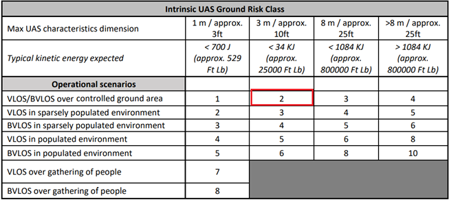
Hence, step #2 of SORA results in Initial GRC = 2.
Step 3. Final GRC Determination
- WHAT ARE YOU BEING ASKED?
The initial GRC can be reduced with a set of mitigations. Table X provides a list of potential mitigations available to the applicant and the associated correction factor. A positive number denotes an increase in the GRC, while a negative number results in a decrease in the GRC.
The final GRC is established by adding all correction factors and adapting the GRC by the resulting number.
- IN OUR EXAMPLE…
In order to reduce the Initial GRC (2), some mitigation actions are applied.
M1 mitigations are “strategic mitigations” intended to reduce the number of people at risk on the ground. Since the flight is taking place over a controlled ground area, this type of mitigation will not be applied.
M2 mitigations are intended to reduce the effect of ground impact once the control of the operation is lost. This is done by reducing the effect of the UAS impact dynamics. In order to reduce the GRC, the UAS will contain all elements required for the activation of a parachute. This mitigation will be a Low Robustness which means a variation in the GRC of 0.
M3 an Emergency Response Plan (ERP) will be defined in the event of loss of control of the operation. Due to the same reason as mentioned in M1 (high difficulty in ensuring the number of people involved), the ERP will be a Medium Robustness mitigation, which means it will not affect the final GRC.
As indicated in the following table and taking into consideration the mitigations applied, the Final GRC is 2.
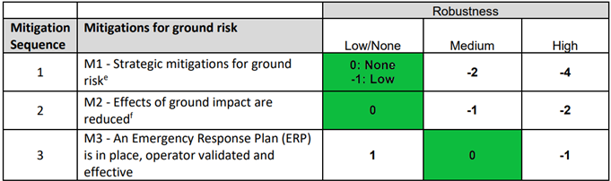
In consequence, the final GRC is determined as follows:
Final GRC = 2 – 0 – 0 – 0 = 2
In the next post, we will cover the rest of the steps of the SORA process, which end by determining the Operational Safety Objectives (OSOs) for the assessed CONOPS.
0 Comments